


ZZZZZZ, Alger County, Michigan
About
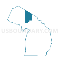
Outline

Summary
| Unique Area Identifier | 595763 |
| Name | ZZZZZZ |
| County | Alger County |
| State | Michigan |
| Area (square miles) | 4,110.62 |
| Land Area (square miles) | 0.02 |
| Water Area (square miles) | 4,110.60 |
| % of Land Area | 0.00 |
| % of Water Area | 100.00 |
| Latitude of the Internal Point | 46.67570150 |
| Longtitude of the Internal Point | -85.96643010 |
Maps


Graphs
Select a template below for downloading or customizing gragh for ZZZZZZ, Alger County, Michigan


Neighbors
Neighoring Voting District (by Name) Neighboring Voting District on the Map
- Voting District 0030446000001, Alger County, MI
- Voting District 0031196000001, Alger County, MI
- Voting District 0033338000001, Alger County, MI
- Voting District 0035620000001, Alger County, MI
- Voting District 0035622000002, Alger County, MI
- Voting District 0036082000001, Alger County, MI
- Voting District 0955044000001, Luce County, MI
- Voting District 1031566000002, Marquette County, MI
- Voting Districts not defined, Marquette County, MI
- Voting Districts not defined, Luce County, MI
- Voting Districts not defined, Keweenaw County, MI
Top 10 Neighboring County Subdivision (by Population) Neighboring County Subdivision on the Map
- Chocolay charter township, Marquette County, MI (5,903)
- Munising township, Alger County, MI (2,983)
- McMillan township, Luce County, MI (2,692)
- Munising city, Alger County, MI (2,355)
- Au Train township, Alger County, MI (1,138)
- Burt township, Alger County, MI (522)
- Onota township, Alger County, MI (352)
- Grand Island township, Alger County, MI (47)
- County subdivisions not defined, Marquette County, MI (0)
- County subdivisions not defined, Alger County, MI (0)
Top 10 Neighboring Place (by Population) Neighboring Place on the Map
Top 10 Neighboring Elementary School District (by Population) Neighboring Elementary School District on the Map
Top 10 Neighboring Unified School District (by Population) Neighboring Unified School District on the Map
- Marquette Area Public Schools, MI (32,158)
- Calumet Public Schools, MI (8,473)
- Tahquamenon Area Schools, MI (7,851)
- Munising Public Schools, MI (5,972)
- Burt Township School District, MI (522)
Top 10 Neighboring State Legislative District Lower Chamber (by Population) Neighboring State Legislative District Lower Chamber on the Map
Top 10 Neighboring State Legislative District Upper Chamber (by Population) Neighboring State Legislative District Upper Chamber on the Map
Top 10 Neighboring 111th Congressional District (by Population) Neighboring 111th Congressional District on the Map
Top 10 Neighboring Census Tract (by Population) Neighboring Census Tract on the Map
- Census Tract 1, Alger County, MI (3,869)
- Census Tract 2, Alger County, MI (2,742)
- Census Tract 9602, Luce County, MI (2,147)
- Census Tract 11, Marquette County, MI (1,565)
- Census Tract 9900, Alger County, MI (0)
- Census Tract 9900, Luce County, MI (0)
- Census Tract 9901, Keweenaw County, MI (0)
- Census Tract 9900, Marquette County, MI (0)
Top 10 Neighboring 5-Digit ZIP Code Tabulation Area (by Population) Neighboring 5-Digit ZIP Code Tabulation Area on the Map
- 49855, MI (33,561)
- 49868, MI (5,409)
- 49862, MI (5,025)
- 49806, MI (627)
- 49884, MI (552)
- 49839, MI (479)
- 49822, MI (220)